GIS & APPLICATION DEVELOPMENT
DPRS is an “One-Stop-Shop” for assisting with your GIS, Geo-Databases, and GIS Application Development needs. Our technical team consisted of: a) GIS technicians, analysts, and programmers, b) data and database experts, and c) web-designers/programmer and technical writers, is ready to offer its services ensuring the maximum level of customer satisfaction. Our services include but are not limited to:
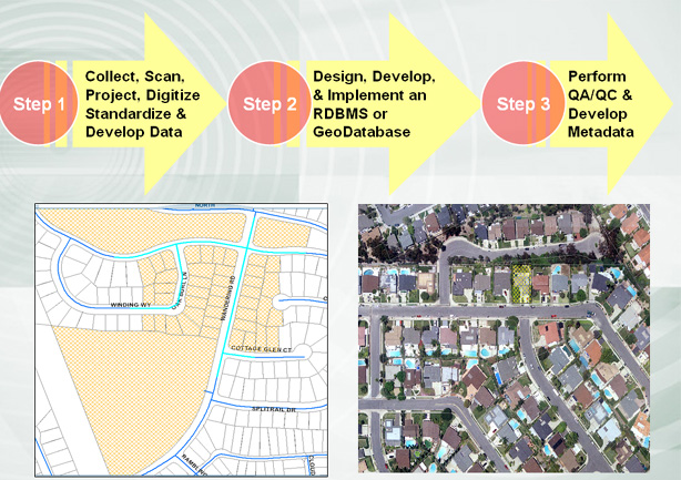
GIS Data Conversion: From hardcopy format (paper maps, sketches, engineering drawings etc) to digital format (CAD, MicroStation, GIS, Database/Geo-Database etc). Data format conversion among different digital file formats (i.e. CAD to/from Shapefile, KML to/from Shapefile or CAD) is also available.
GIS Data Cleanup & Standardization: We utilize advanced error -tracking and -correction programming routines to ensure data quality, consistency and integrity. We perform spatial adjustment, ortho-corrections, attribute update/correction, geometric adjustments, sliver and overlap elimination etc. We work with vector, raster and tabular data formats.
GIS Data Analysis & Mapping: We provide a wide range of spatial and statistical analysis, custom data modeling, 3D data analysis, geospatial analysis, and advanced data management. We also work with LIDAR data and aerial imagery to generate DEM and derivative raster data.
Enterprise Geo-Database Development: DPRS is a leader in the architecture, development, implementation, and optimization of Enterprise Geodatabases & Systems designed to provide: seamless data integration, high performance, efficient data management, and scalability to accommodate present and future needs.
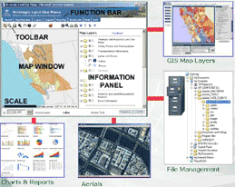
GIS Application Development: Our technical team has programming experience in Visual Basic, Java, C#, C++, ASP.NET, HTML, KML and many more. We also have worked with the following web mapping tools: Geocortex, Silverlight, Google APIs, and Widgets.
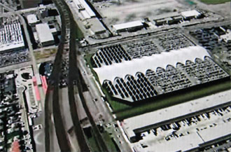
GIS 3D Visualization: We also have experience of
creating 3D GIS visualizations, composing 3D GIS video demonstration
from flyover and walk-through, and integrating ESRI GIS with Google
Earth to generate realistic video streaming with sound.
Contact or visit us to discuss your project and provide you with innovative and cost-effective solutions and services.
Services
Data & Database
Data Conversion, Cleanup, Standardization, Analysis, Mapping, and Database Development.
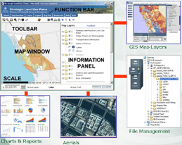
GIS & Application Development
GIS Application Development, Geo-Database Design, Optimization & Implementation.
Planning
Land Use & Transportation Planning, Regional Economic Development, and Forecasting.

Business Solutions
Provision of Complete Business Solutions Using "Cutting Edge" Hardware and Software.
Research & Development
DPRS R&D Activities in GIS Application Development, Automation Systems, 3-D Modeling etc.